
Chad Prepares to Be an Oil Producer

Lagos, Nigeria
Contents
Exploration History
Geology
The Petroleum Geology
Project Potential
Barring any major, unforeseen hitch, the dusty, arid Republic of Chad, located in West Africa northeast of regional oil giant Nigeria, will become the world's 76th producer of oil in the next three years. Environmentalists have had their day of protest, public commentators their say, and transparency-minded NGOs have slammed the Chad/Cameroon Development Project, by which the Chadian oil will be ferried to market.
In the final analysis, the front-end engineering of the 1,500 km pipeline from Chad's oil fields to the Kribi coast of Cameroon will go on, with first oil in 2003. Pipeline construction will take three years. The life of the oil fields is estimated at 30 years.
No other country on the planet needs the exploitation of profitable natural resource as desperately as Chad. This landlocked country, spread over 1.284 million sq km, an area three times the size of California, has a population of only 7.5 million, yet is hardly able to feed its people. With per capita GNP estimated at $220, Chad is the world's fifth poorest country. Out of every 1,000 children 115 die at birth. Malnutrition is rife. Life expectancy is 46 years, about 30% less than the world average. And 85% of the population depends on agriculture, including livestock. The government is keen on increasing the GDP of $7.5 billion and improving the economic growth rate of 2.9% which is almost at parity with the population growth rate of 2.65%.
Chad has no refineries. The country's fragile downstream infrastructure is easily rattled by problems beyond her borders. Persistent refinery problems in Nigeria last year aggravated a shortage of petroleum products in Chad, for Nigeria accounts for 60% of Chad's import of refined petroleum products.
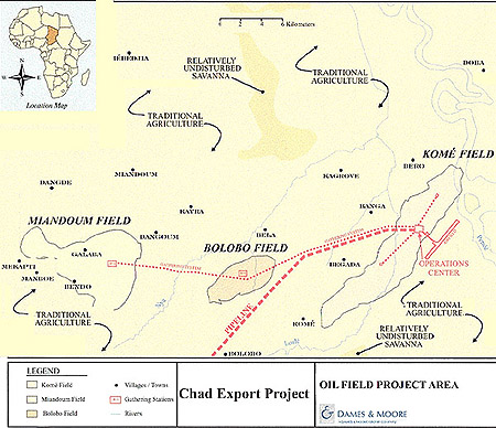
This is the profile of a country in whose bowels lie the Doba and Doseo Basins, twin basins that will deliver Chadian oil via Kribi after mid-2003.
The pipeline project is proposed by partnership involving the government of Cameroon and Chad; Esso Exploration and Production Chad (project operator); Societé Shell Tchadianne de Recherches et d'Exploitation, Elf Hydrocarbures Tchad, and the Cameroon Oil Transportation Company (Cotco).
Exploration History: (back to top)
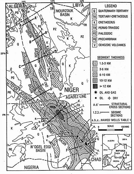
For Chad, it has been a long walk to becoming an oil producer. The country's sedimentary terrain is part of the West and Central African Rift System (WCAS), a stretch of geologic infill that runs from northern Nigeria, Niger, and Chad to the Central African Republic, Libya, and Algeria. Surface geological exploration in this region began with the Bureau de Recherches Petrolière in 1952-55. Shell came in 1955, and Exxon and Mobil arrived to conduct similar studies in 1959. The first hydrocarbon exploration permits in the region were granted to Saphyr Petroleum and Petropar in 1962. But Chad was not interpreted as a rift system geology until Conoco showed up in 1969.
Texaco and Amax Oil and Gas began exploring northeastern Niger in 1970, and Conoco and Shell began studying the Central African Republic in 1973. It was Conoco, however, that got a handle on the area's geology before any other company, drilling the first oil well in the Termit Basin, near Lake Chad, in 1974. The group whose work led to the unveiling of the commercial reservoirs that will make Chad an oil producer was, however, a consortium comprised of Exxon, Shell, and Chevron. It started work in 1973 on an exploration permit of 104,234 sq km.
Threats to the Project
The commercial viability of the Doba and Doseo Basins was uncovered during the recession of the late 80s to early 90s. By 1994, with the industry's improved economy, the reserves' location became more of a negative development factor. Environmentalists attacked the idea of a pipeline from the start, arguing it would damage sensitive biodiversity areas such as the Mbere rift valley in Cameroon's Adamawa province and the Deng Deng forest in its East province. Since 900 km of the 1,050-km pipeline will pass through Cameroon, environmentalists pointed to other localized areas of sensitivity, including special vegetation, river crossing, wetlands, and swamps, and the fragile littoral rainforests of Cameroon, home to the minority Baka pigmies.
In response, the joint venture partners have "walked" the pipeline route to identify and consult all landowners and users and avoid environmental and social disturbances. In the process a center line survey was completed and some 65 route adjustments were made. Plans were also made for providing benefits to the indigenous peoples in the areas of health, education, and agriculture. Pre-construction activities would involve major rehabilitation of certain roads and bridges in Cameroon to transport equipment and material.
The governments of Cameroon and Chad both rank very low in maintaining human rights, and pressure from both environmentalist and human rights groups has been more successful than any other in delaying the project. In fact, the World Bank, which is enthusiastically in favor of the project, had to delay the disbursement of US$90 million or three percent of the $3-billion project because of environmental and human rights complaints. These have largely forced the hand of joint ventures partners in adjusting pipeline routes and addressing the quality of life of host communities in the oil fields and along the routes.
Geology (back to top)
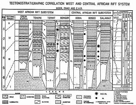
The Doba and Doseo Basins belong in the West and Central African Rift system, which extends 4,000 km from the Gao Trough in Mali to the Anza Basin in Kenya. The rift system is subdivided into two coeval, cretaceous, genetically related but physically separated rift subsystems; the West African Rift Subsystem(WAS) and the Central African Rift Subsystem(CAS).
Five major tectonic phases define the geologic framework and rift distribution of WCAS:
- Pan African continental consolidation (750-550Ma)
- Paleozoic-Early Mesozoic Platform Development (450-130Ma)
- Early Cretaceous, early rift (130-98 Ma) to Late Cretaceous, late rift(98-75Ma)
- Maastrichtian-Paleogene rift and emergent (75-30 Ma)
- Neogene-Recent (mainly emergent)
Structural lineaments, faults and fractures that were inscribed during the first phase (Pan African consolidation) became the artifacts that provided the direction for the cretaceous rifts (Phase 3).
As in most sedimentary terrains in Africa, the rifts in the WCAS originated from the break-up of the supercontinent Gondwana and the opening of the South Atlantic Ocean, beginning from ~130 Ma. But the crustal plate drivers, which created the South Atlantic, lacked the necessary energy to separate the intra-African crustal blocks in the WCAS region. The most current model of the WCAS is that it resulted from simultaneous lateral divergence along the structural lineaments created during the Pan African continental consolidation.
WCAS rifts became fully developed across Middle Africa at about 108Ma, filling with entirely continental sediments. As the region continued to rift, a regional cratonic subsidence occurred at about 98Ma to 75Ma, resulting in a major marine transgression over Mali, Algeria, Nigeria and Niger. Widespread epicontinental seas biodirectionally transgressed the WAS region and west of it, from the Tethys via Mali and Algeria and from the South Atlantic through the Benue Trough in Northern Nigeria. This transgression is coincident with the worldwide Late Cretaceous eustatic sea level High Stand.
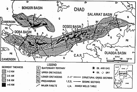
The famous Santonian squeeze impacted on the sediments in the region ~ 85Ma, folding most of the basins, including the Doba and Doseo. These two basins, as well as the Salmat, had effectively been one basin; they were separated into three discrete basins by dextral movements along the Bogorop fault zone.
The Doba & Doseo Basins
The Doba and Doseo basins situate directly in the Central African Rift Subsystem, (CAS) of the WCAS. The CAS extends from Cameroon across Chad, CAR, and Sudan to Kenya.
Doba is a rotated, complex, extensional rift, spanning a length of 300 km and a width of 150 km. It contains a sedimentary column up to 7,500 meters thick of Neocomian to Recent continental clastics and has an estimated sediment volume of 210,000 km3. The basin comprises several southeast plunging half grabens. These are steep-sided to the northeast at the west end of Doba, and are separated by a roughly northeast-southwest aligned accommodation zone (Rosendahl et a1., 1986) or transfer zone (Morley et a1., 1990) from half grabens which are steeps sided on their southwest sides at the eastern end of Doba. Fourteen exploration wells were drilled in Doba of which six were oil discoveries.
Doseo Basin
Doseo is a transtension rift in a "restraining bend" according to Christie, Blick, and Biddle (1985), along the south flank of the Borogop Fault Zone which separates Doseo from the adjacent Doba Basin on the west. Doseo is 480 km long, 90 km wide, and contains a maximum sedimentary succession of 7,700 meters of chiefly lower Cretaceous terrigenous sediments whose estimated volume is 360,000 km3.
Unlike the Doba and other WCAS extensional rift basins, the transtensional, consistently steep to the north asymmetric Doseo Basin exhibits no accommodation or transfer zones or structural polarity shifts of the half grabens within it. It may be that reversals in half graben structural polarities with their attendant accommodation zone (Rosendah et al 1986)are a phenomenon peculiar to extensional rifts.
The Petroleum Geology (back to top)
Oil has been discovered in Lower Cretaceous sandstones in the Doba and Doseo Basins and in Upper Cretaceous sandstones in the Doba Basin. The Lower Cretaceous reservoir, grade from alluvial-fluvial to lacustro-deltatic and turbiditic sandstones. Bed set thicknesses range from 30 meters in fluvial facies to less than three meters in deeper water lacustrine facies. The sandstones are varyingly arkosic. Porosity ranges from 35% down to 2%, normally it is in the 15-20% bracket. Permeability generally decreases with porosity and depth but can acutely vary as a function of lithofacies, grain sizes, and diagenetic cements.
The major Upper Cretaceous reservoirs, are braided stream, point bar, and marginal lacustrine siliciclastics. They are found commonly in stacked channels from 10 meters thick to more than 30 meters thick. The sandstones are arkosic and locally conglomeratic. Porosities are 25% - 32% and permeabilities range from 1,000 to 10 millidarcies. Minor Upper Cretaceous reservoirs are marginal lacustrine sandstones in beds five meters or less in thickness.
The hydrocarbon source beds are situated in the Lower Cretaceous early rift lacustrine shales. There are no Upper Cretaceous hydrocarbon source sediments in any of the CAS basins in Chad or the CAR. The known gross thickness of the kerogen-bearing shale intervals ranges from a few hundred meters in Doba and Salamat to 3,000-4,000 meters in Doseo. The effective individual source bed thickness appears to be from a few meters to several tens of meters (See Figures) and cumulatively can reach several hundred meters. Total organic carbon content is typically 1-4% in Doba, 2-13% with 2.5% average in Doseo and around 2% in Salamat. Rockeval pyrolosis and microscopic examination show that the organic matter type is most commonly type I and III. The apparent type II samples may result from a pyrolized mixture of types I and III. Present day temperature gradients in the three basins average around 2.5-3.0ºC/100 meters, but in some central Doseo area, the gradient reaches 5.92ºC/100. The oil generative window lies between approximately 2,500 meters (8,000 ft) and 4, 500 meters (14,500 ft) interpreted from computerized LOM calculations normalized from vitrinite reflectance and TAI analyses.
There are two seal units in the CAS basins, Lower Cretaceous and Upper Cretaceous. In the Doba Basin, both are present. The Lower Cretaceous lacustrine shale seals range in thickness from less than 30-40 meters to several hundreds of meters. Upper Cretaceous seal beds are flood plain and inter-distributary to lacustrine shales up to 200 meters thick. In the Doseo Basin, the Lower Cretaceous lacustrine shales are the only seals. These are basin wide and constitute seals which range in thickness from a few tens of meters thick up to more than a thousand meters.
Hydrocarbon Characteristics
In the Doba and Doseo Basins, medium to high gravity crudes of similar quality in the Lower Cretaceous have been tested at rates up to 2,200 b/d oil. The oils are paraffinic, API gravity ranges from 23.8o to 39o and averages around 34o. Gas oil ratios measure 200-12,000 scf/STB, however the oil is generally undersaturated. In Doseo, one well tested a gas cap of 8.3 million cf/d. Oil pour point range from 4.4oC to 38oC, but most commonly they are 24o to 32oC, and viscosities are low at around 4 centistokes at reservoir conditions. Sulfur content by weight is 1% to 2.9% in Doba and less than 0.04% in Doseo. The oils may be in stacked reservoir with multiple oil water contacts.
In the Doba Basin, the second oil type consisting of heavy to medium grades, has been tested at rates of up to 2,368 b/d in the Upper Cretaceous. These crudes are generally viscous, varyingly biodegraded, waxless, with API's from 15o to 24.6o. Their gas oil ratio is less than 15 scf/STB, pour points are low—12oC to 7oC and sulfur content is 0.002% or less. This oil type was source from the Lower Cretaceous.
Project Potential (back to top)
The immediate benefit of such a relatively big project in such poor countries is the employment opportunities. Some 50,000 construction-related jobs will be created. At least 400 people would be employed in operations, according to Cotco and Exxon. New skills will come and much of the dilapidated infrastructure will be rebuilt.
The World Bank involvement in this project provides a guarantee to these two countries that would otherwise have lacked the capital for equity, either due to their impoverishment or their odious human rights records. The World Bank assists in revenue management partners estimate the economic development value of the project has been estimated at $8.5 billion for Chad and $900 million for Cameroon. This includes direct and indirect economic activity, oil field revenue, and pipeline taxes, as well as compensation and cost to Chad and its citizens over the project's lifetime. Doubtlessly, there will be vast improvement in the infrastructure; transportation, health and education, even if, as is likely going to be the case, the project breeds a large group of corrupt bureaucrats and businessmen.