Co-ordinate Systems for UKCS Petroleum Exploration & Production Licenses

The SIMA Consultancy Limited, London
Co-ordinates describing a position on the earth are only unambiguous if the co-ordinate system to which they are referenced is identified. Geographical co-ordinate system components are geodetic datum and ellipsoid. Projected co-ordinate systems are geographical co-ordinate systems with a projection transformation applied.
An important step forward has recently been taken to ensure the spatial integrity of the UK's offshore geotechnical data. On 21st December 1999, the Oil and Gas Licensing Division of the UK Department of Trade and Industry (DTI) published a notice in both the London and Edinburgh Gazettes to clarify the co-ordinate systems to which license boundaries on the UK Continental Shelf (UKCS) were referred. These publications are official newspapers of the Crown, and as such, represent legal instruments of notice for the UK Government. It is often used to make notices that are statutory in nature and can be used in legal proceedings.
The Gazette notice refers specifically to the contents of the schedule attached to license agreements of UKCS offshore license boundaries. It acknowledges there may have been some uncertainty in the past and sets out the DTI's interpretation of license boundary co-ordinates in existing licenses. It also confirms the position, until further notice, as to the geographic co-ordinate systems that may apply in the case of future license awards.
Petroleum license boundary co-ordinates have previously been referenced to "European Datum". This term is not a precise one. Several versions of European Datum (ED) exist.
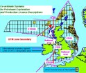
The DTI has chosen to be pragmatic in its clarifications. Where the ambiguity in the term European Datum is small, which happily coincides with areas of mature UKCS petroleum activity, the co-ordinate system in use by the majority of the industry has been adopted. Where the differences in the interpretation of European Datum are potentially significant, a system has been adopted that can be considered to be coincident with the co-ordinate system used by satellite navigation GPS (Global Positioning System). A dividing line has been chosen (Longitude 6°W in ED50 terms) which is coincident with a UTM zone boundary. This dividing line has been dubbed "the Thunderer Line".

East of the Thunderer line lies the majority of the more mature exploration and production activity on the UKCS. At the level of positional uncertainty here, there is no business justification for disrupting current practices for the majority of the industry. To the east of this line, the meaning of "European datum" is clarified as ED50. For UKCS petroleum purposes, ED50 is defined relative to ETRF89 (European Terrestrial Frame 1989) and GPS's WGS 84 (World Geodetic System 1984) using accepted industry transformation methods and transformation parameter values, consistency being preferred to absolute accuracy.
West of the Thunderer Line there is little data existing and, as yet, no oil & gas production. Hence, adoption of a technically preferred system is acceptable and encouraged. Here "European Datum" is clarified as ETRF89. The safety risk is reduced through adopting a system which for all practical purposes is that used by GPS. The geodetic datum adopted is also consistent with the UK international boundary definitions to the west of Britain.
The Thunderer Line was chosen to be coincident with a UTM zone boundary, where there is normally a discontinuity of projected co-ordinates. Therefore, there is no change in the number of projected co-ordinate systems in use on the UKCS. For landward areas of Scotland, England, and Wales there is no change in the use of the Ordnance Survey ® GB National Grid and its geodetic datum OSGB 1936. For landward areas of Northern Ireland there is no change in the use of the Irish National Grid and its geodetic datum TM65.
Besides declaring the geographic co-ordinate systems to use, the Gazette notice also declares the transformations applicable for petroleum purposes between ED50, ETRF89, OSGB36 and the GPS satellite navigation system's co-ordinate frame WGS 84. This is a significant step forward in ensuring consistency of use across industry over the whole UKCS.
While the Gazette note refers explicitly to petroleum license boundary co-ordinate descriptions, it should also be considered as standard for associated UK petroleum data management and mapping purposes. The DTI have stated that all data supplied to them should explicitly refer to the co-ordinate system to which it relates. All data acquired after 1st January 2000 should comply with the content of the Gazette notice.
Through a combination of officially declared co-ordinate systems and their transformations, petroleum industry users can now unambiguously merge positional data throughout the UK and its continental shelf. The Gazette notice will change the way we handle and record co-ordinate data, especially to the West of Britain.
Cognisant of the fact that industry may require assistance and guidance concerning the data handling issues that may result from the Gazette notice, the UKOOA (United Kingdom Offshore Operators Association) Surveying and Positioning Committee has released "Guidance notes on the use of co-ordinate systems in data management on the UKCS". This document caters for data users, software vendors, and data vendors and can be downloaded free of charge from the Publications section of the UKOOA website (http://www.ukooa.co.uk). It can also be referenced through the DTI Oil and Gas website (http://www.og.dti.gov.uk). The full text of the Gazette notice, including the transformations applicable for petroleum industry use between the declared geographical co-ordinate systems of WGS84, ED50, ETRF89, and OSGB36, can be found within this document.
