
Geostatistics module released for Stratamodel
Stratamodel 1998.6 contains two major enhancements and additions. First, a new datum field in the seismic import feature that allows the user to adjust the model's datum to be compatible with imported SeisWorks project files. Second, geostatistics have been added to the Stratamodel product line through the (RC)2 module. This feature allows the user to perform data analysis, create variograms and simulate data into Stratamodel attributes.
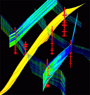
Reservoir simulation via Landmark Graphics' Stratamodel. Courtesy: Landmark Graphics.
"The cooperative working relationship we established last fall with the staff at (RC)2 has clearly produced the benefits for our customers that we anticipated," said John Gibson, Landmark's president and CEO. "As a result of this new release, our Stratamodel users are not only able to integrate different types of data, but they can also assess risks associated with development decisions."
The product's release to the market in less than six months was the result of a very aggressive, intensive development and testing routine. Industry experts in the field of geostatistics provided quality assurance and assisted in the deployment of this software. A usability study was also conducted on the software to improve the interface and make it easier for use by geoscientists with limited geostatistical background.
The software is designed to process associated input data and perform geostatistical simulations of geological and reservoir properties in Stratamodel's three-dimensional geocellular model. Simulation results can then be analyzed in the (RC)2 product to compare the results to the original input data. This provides Landmark with the ability to deliver a geostatistical module within Stratamodel that addresses the basic geostatistical needs of most asset team geoscientists. The module will be provided by (RC)2 and marketed by Landmark as an (RC)2 module.
"Stratamodel has a long standing reputation in the industry for providing leading-edge 3D modeling capabilities on faulted models," said Bill Bashore, vice president, (RC)2 Technology. "Now, the combination of property modeling of the (RC)2 module in Stratamodel brings the best of both worlds together in 3D reservoir characterization techniques."
Source: Landmark Graphics