TGS Announces Declaration Refocus, A Next Generation Imaging Program In The U.S. GOM

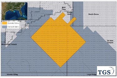
Asker, Norway (GLOBE NEWSWIRE) - TGS announced today the Declaration Refocus next generation M-WAZ imaging program in Mississippi Canyon in the U.S. Gulf of Mexico. The new, high-end re-imaging workflow is designed to provide enhanced imaging and greater illumination of prospectivity in the area. The program comprises data covering more than 380 Outer Continental Shelf (OCS) blocks (~8,860 km2) from orthogonal 3D WAZ programs previously acquired by TGS using WesternGeco Q-Marine and CGG StagSeis seismic systems between 2010 and 2015. Full product delivery of Declaration Refocus is expected at the end of 2020, which will solidify TGS’ core position in the U.S. Gulf of Mexico.
Kristian Johansen, CEO of TGS, said, "We are extremely pleased to begin the next phase of imaging over the data rich Declaration survey. By applying our most advanced imaging techniques to this highly-successful region TGS will further illuminate key subsurface structures and continue to provide the industry with unprecedented insight and continuous coverage across this prolific basin. Combined with our vast library of well information and our trusted imaging solutions, we continue to provide customers with the most comprehensive range of subsurface data in the Gulf of Mexico.”
The new imaging project will process data from the prolific Mississippi Canyon, Viosca Knoll and De Soto Canyon areas using the latest imaging technologies to provide a significant uplift in data quality. Particular attention will be given to increasing frequency content and resolution throughout the entire data section with additional focus on the Norphlet formations. The imaging process will also provide enhanced velocity and salt models. The Declaration area is one of the most active for E&P companies in the U.S. Gulf of Mexico and will benefit from two licensing rounds every year under the BOEM 2017-2022 Five-Year Program.
This project is supported by industry funding.
About TGS
TGS provides multi-client geoscience data to oil and gas Exploration and Production companies worldwide. In addition to extensive global geophysical and geological data libraries that include multi-client seismic data, magnetic and gravity data, digital well logs, production data and directional surveys, TGS also offers advanced processing and imaging services, interpretation products, and data integration solutions.
All statements in this press release other than statements of historical fact are forward-looking statements, which are subject to a number of risks, uncertainties and assumptions that are difficult to predict, and are based upon assumptions as to future events that may not prove accurate. These factors include TGS' reliance on a cyclical industry and principal customers, TGS' ability to continue to expand markets for licensing of data, and TGS' ability to acquire and process data product at costs commensurate with profitability. Actual results may differ materially from those expected or projected in the forward-looking statements. TGS undertakes no responsibility or obligation to update or alter forward-looking statements for any reason.
For more information, visit TGS.com
© 2019 GlobeNewswire, Inc. All Rights Reserved.
Source: TGS
